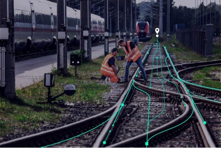
The agreement sets the tone for the future of railway asset management, combining regular satellite radar data with advanced analytics to map deformation, flooding and surface changes, while building upon Network Rail’s decades of operational expertise and proven asset management processes.
SatSense Ltd, a leading InSAR (Interferometric Synthetic Aperture Radar) technology specialist based in Leeds, has secured a landmark multi-million-pound, multi-year contract with Network Rail to deliver network-wide ground deformation monitoring, flood mapping and change detection services using satellite radar technology
The innovative approach paves the way for redefining geotechnical asset management and setting a new standard for sustainable infrastructure monitoring.
Integrated InSAR Monitoring Services
Under the agreement, SatSense will deliver processed InSAR data and derived services that integrate into Network Rail’s earthwork asset management systems, utilising data from satellites such as the Sentinel-1, NISAR and TerraSAR-X constellations.
The approach aims to enable a transition to reduce reliance on repeat on-site examinations, which can be costly, subjective and untimely.
“We are delighted with this appointment – it is a testament to the vision of decision-makers in Network Rail, and the quality of work delivered by the Network Rail and SatSense teams on this theme over the years.” said Dr. Matthew Bray, CEO of SatSense Ltd. “We’re excited to work towards realising the benefits that remote sensing offers in rail, enhancing safety and reliability at scale.”
Operational Applications
The implementation will deliver several key operational advantages over traditional monitoring methods:
- Cost Savings: Providing a cost-effective alternative to scheduled site visits across the entire network
- Enhanced Safety: Reduces risk to personnel by minimising time spent on the track and on slopes, through continuous remote monitoring capabilities
- Improved Efficiency: Enables faster data collection, eliminating time constraints of ground-based surveys, optimising on-site time and unlocking capacity for critical geotechnical assessments
- High Data Accuracy and Consistency: Millimetre-level precision enabling repeatable measurements over time for trend analysis while reducing human error and subjectivity
- Continuous and Proactive Monitoring: Near real-time analysis after each satellite overpass, enabling predictive maintenance and improved data-driven decision making rather than reactive responses
- The implementation will build upon, rather than replace, Network Rail’s decades of manual examination expertise, using existing asset knowledge to validate and interpret Earth Observation data for enhanced asset management decisions.
Network Rail’s decision to utilise a suite of remote sensing technologies to enhance and optimise existing asset management systems reflects the organisation’s commitment to operational excellence.
Market Impact and Global Implications
This first network-wide implementation is expected to influence the adoption of integrated InSAR solutions across the global rail industry, with other major operators evaluating similar approaches. The contract demonstrates the commercial viability of integrated satellite-based infrastructure monitoring and establishes new benchmarks for railway asset management.
The implementation positions the UK at the forefront of railway innovation, with Network Rail leading the adoption of advanced monitoring technologies in major rail operations.
Figure: Representative image of how SatSense's InSAR data will be integrated into Network Rail's internal GIS software to monitor ground movement trends along the rail corridor